

A strong-to-very-strong El Niño will impact winter 2026-2027

October 16, 2026

Weather has been creating its own World Series. First there was the extended and hot, dry summer across large sections of the Great Plains. Then rain arrived just in time to disrupt harvest activities, especially in Kansas and Nebraska — and lately plenty of rainfall. The main event now through this winter is a greater than 83% chance of a near-record-strong El Niño climate phenomenon, according to the Climate Prediction Center in its winter weather outlook released Thursday, Oct. 15.
In the short-term forecast (eight to 14 day outlook) there is a risk of heavy snow from Colorado northward into Wyoming and southern Montana between Oct. 22 to 28. During that same period, strong winds are expected down the Front Range. Windy conditions are also forecast eastward through the Plains states.
Also in the last week of October, heavy precipitation is forecast from eastern Nebraska and Iowa, south into Kansas and Texas.
The current very strong (meaning very warm ocean waters) El Niño has and will continue to affect the U.S. So far, this past summer through the current autumn season, it has pushed increased moisture across portions of the Intermountain West and the High Plains and then east generally across Nebraska, Iowa and other points east.
“This happened mainly because of all the strong hurricanes we’ve experienced in the eastern Pacific that move northward and eventually get sucked up by the jet stream across Mexico and the U.S.,” said Doug Kluck, retired, director of the National Oceanic and Atmospheric Administration Central Region Climate Services. Odds are we will continue to see this vast pool of much warmer than normal water being tapped for moisture more and more, as the jet stream moves seasonally south in late fall and through the winter, Kluck added.
“Due to the likelihood of a record-strong El Niño, odds are tilted toward winter wetness (December 2026 through February 2027) across the central and southern Great Plains, extending at least as far north as Nebraska,” said Brad Rippey, chief meteorologist, USDA’s Office of the Chief Economist, World Agricultural Outlook Board in Washington, D.C.
The autumn rainfall is also replenishing topsoil moisture and should help to revive rangeland and pastures, if not now, then next spring, Rippey added.
COLORADO
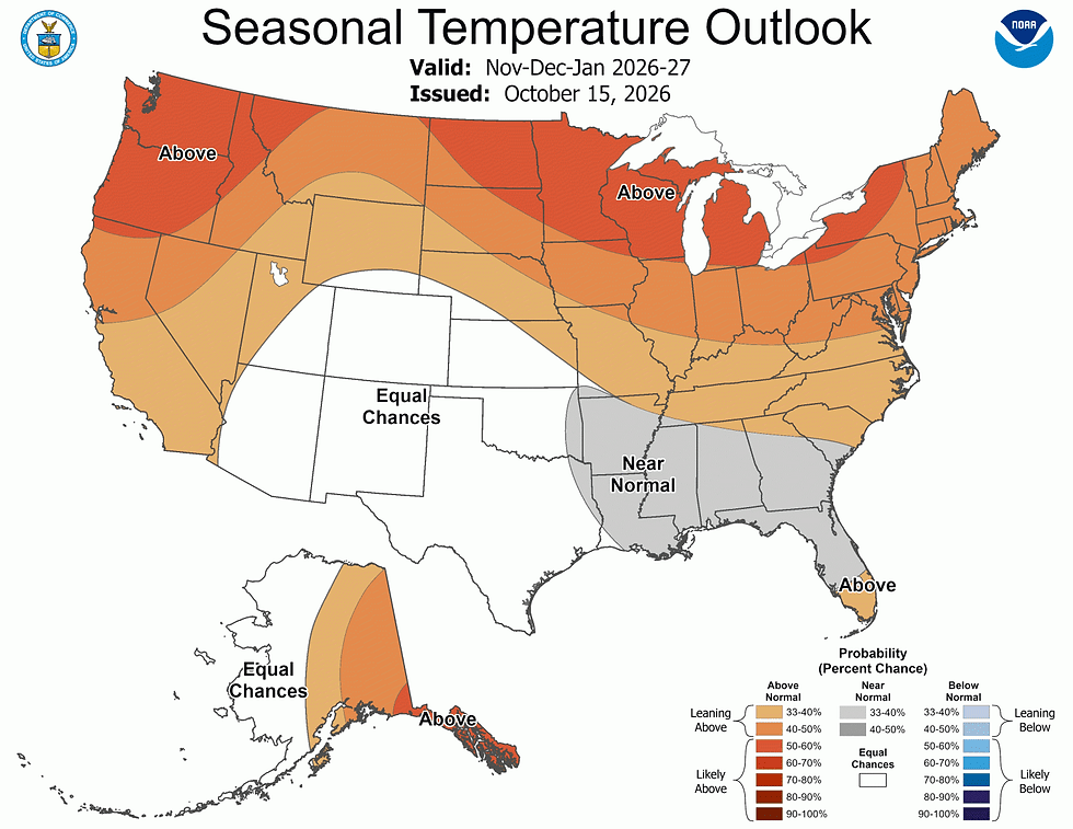
Colorado is forecast to receive above-normal chances for wetter than normal conditions across the eastern Plains and parts of southern Colorado this winter, according to the Climate Prediction Center. The greatest chances for above-average precipitation are in southeast Colorado. Regarding temperatures, Colorado is situated in the “equal chances” category, meaning that there is roughly equal likelihood of seeing above normal or below normal temperatures. Much of central and northwest Colorado are also in the “equal chances” category for precipitation, so roughly equal chances of seeing above or below normal precipitation.
“This CPC outlook aligns fairly closely with what we might expect from a strong El Niño winter in Colorado. There is some evidence in our historical records that when El Niño is in place, there are some areas of Colorado that tend to be wetter than average. This signal is strongest in Colorado in fall and spring, but there is a positive relationship between the two in the winter as well (particularly over the eastern Plains)” said Allie Mazurek, PhD., engagement climatologist at the Colorado Climate Center, Colorado State University.
Examining historical snowpack numbers, Colorado’s southern basins have historically seen above-normal snowpack during El Niño winters, Mazurek said, noting that in the state’s northern basins, there isn’t as strong a relationship between El Niño and snowpack, and that some of those basins have been historically wetter during La Niña.
“Coupled with historical patterns during El Niño, there are reasons to be optimistic about a winter that leans wetter. However, the wet signal in the models is much weaker in Colorado than other places (like California), so seeing those wetter conditions is by no means a done deal,” Mazurek told The Fence Post.
WYOMING
El Niño is here and building with a better than 80% chance of a strong El Niño persisting at least into the January to March 2027 timeframe, and not switching to a neutral state until the April to June time period. It is expected to rival or exceed the 2015/2016, 1997/1998, and 1982/1983 events. Wyoming is in that neutral zone between opposing El Niño Southern Oscillation influence, so outlooks, especially for precipitation tend to be a bit less certain. The southern part of Wyoming, especially the southeast, could expect to finally see some above-normal precipitation.
“This would be very helpful given the bleak season last year. Conversely, the north, especially northwest Wyoming would typically be seeing below-normal precipitation and both of these situations are reflected in the seasonal outlooks, although much of Wyoming in between sits in an area where there are equal chances of above normal, normal, or below normal precipitation,” said Tony Bergantino, director, Wyoming State Climate Office and Wyoming CoCoRaHS State coordinator. (CoCoRaHS stands for Community Collaborative Rain, Hail and Snow Network.)
However, winter temperatures lean toward above-normal, which does not bode well for snowpack, Bergantino added.
Looking ahead, the historical probability of seeing multi-year La Niña’s following a strong El Niño event is a concern and, while the relationship is not absolute, Bergantino suggested it needs to be considered, since those conditions could worsen the state of drought especially in the south and the eastern Plains.
On a positive note, Laramie, Wyo., received about 4 inches of very wet snow on Oct. 15.
KANSAS
In Kansas, recent dry trends have resulted in some progress with harvest.
“However, we are having issues with corn sprouting and both corn/soybeans falling over with the previously wet conditions and some wind,” said Christopher “Chip” Redmond, meteorologist, K-State Weather Data Library/Mesonet manager, adding that rains have been ideal for folks who have planted winter wheat and with optimal/wet soil moisture conditions.
With frequent episodes of Pacific/Gulf influences as slow-moving storm systems continue to bring moisture, (even with September dryness) some areas are running 300%-plus of normal the last 30 days with a lot of drought improvement.
“As a result, we have observed increased reports of standing water and flooding that’s slowing progress of harvest and may impede wheat progress,” Redmond said. As we enter the drier time of the year with a potential freeze this weekend (Oct. 17) for many, that moisture is likely to sit there for the coming months with an ample soil profile.
This may increase disease stress and inflate flooding concerns this winter and spring. If we don’t observe enough cold to push wheat into dormancy, which seems likely, excessive growth and easier cold damage is also a concern, Redmond added.
Kansas has an increased chance of winter storm impacts resulting in snow and/or maybe ice into 2027 with El Niño continuing to affect the central U.S. through this winter with substantial bouts of moisture.
“With the increased quantities of systems overall, some cold is bound to be integrated into storms later this winter, which aligns with signals from the negative PDO (Pacific Decadal Oscillation). Despite that, any cold period will be limited with warmer than normal temperatures slightly favored into spring,” Redmond forecasted. Lastly, we will have to watch ENSO, as some models suggest a quick flip to La Niña which may result in drier conditions next summer and into 2028.
NEBRASKA
The CPC’s three-month outlook shows above average precipitation favored for most of Nebraska. Above average temperatures are also likely, especially across the northern section of Nebraska.
“This outlook is heavily tied to the record strong El Niño and the enhanced subtropical jet stream that would help favor a more active weather pattern in the central Plains. Harvest progress may be slow, especially if October finishes wet,” said Eric Hunt, Ph.D., assistant Extension educator of Agricultural Meteorology and Climate Resilience, University of Nebraska-Lincoln.
Winter storms would also be a possibility once we get deeper into winter — and any heavy rain events this winter in east central or southeast Nebraska could lead to flooding concerns. Drought is expected to improve in the Nebraska Panhandle, but it’s not clear that significant relief will be delivered in the next three months.

SOURCE: theFencePost, October 16, 2026


